Geology
Spearfish Canyon… Oldest, Most Magnificent Canyon in the West
 The genesis of Spearfish Canyon spans a time interval twelve-times greater than that of the Grand Canyon, and because of the canyon’s rich vegetation, wears the mantle of being “the most magnificent canyon in the west”. The genesis of Spearfish Canyon spans a time interval twelve-times greater than that of the Grand Canyon, and because of the canyon’s rich vegetation, wears the mantle of being “the most magnificent canyon in the west”.
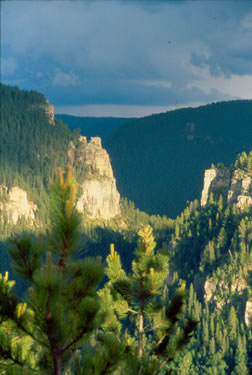
Evolution of Spearfish Canyon began about 62 million years ago (mya) although its present formation began only about 5 mya. At this later time, carving of the inner gorge, known today as Spearfish Canyon, began by the erosive power of the rushing stream. The high canyon walls and deep canyon floor are composed of sandstone, shale and, dominantly, limestone deposited in ancient oceans.
In this latest episode of development, the sculpting of the 1,000 foot deep Spearfish Canyon continued during the same time period that the Grand Canyon was carving a 5,000 foot deep gorge. Although of lesser depth, Spearfish Canyon has the distinction in history of development over a period twelve times longer than that of the Grand Canyon. The distinctive ledges seen in Spearfish Canyon, although substantially less thick than those of the Grand Canyon, consist of rocks of the same ages and similar types.
The “Rise and Fall” of the Black Hills

Three hundred to 500 million of years ago, long before the Black Hills rose, western South Dakota was part of a vast plain standing near sea level. At times, it lay below the sea level of repeated invasions of numerous shallow inland seas that divided the North American continent. Each of the seas deposited successive layers of sediments until about 7,500 feet of flat strata had accumulated.
The Black Hills dome started to rise around 62 mya, probably related in some way to the collision between the floor of the Pacific Ocean and the North American continent. Had the Black Hills retained its sedimentary overlay from deposits of the visiting oceans, they would today be a mountain range rising out of the prairie to an elevation of nearly 15,000 feet. But, because of erosion, about 7,500 feet of the mountains were removed, and part of the material now exists as the popular moonscape of the Badlands National Park. Within the mountain range, hard rocks form the peaks, ridges and plateaus, while softer rocks became valleys and gorges.
As the Black Hills began bulging upward above the surrounding plains, the area hosted a climate much like that of present-day Louisiana. At that time, molten magma from as much as 30 miles below the earth spud into the fractured rock rising into massive domes and along narrow dikes. Domes such as Terry Peak, Devil’s Tower and Bear Butte were created. The dikes were veins of gold that later fostered the Black Hills Gold Rush of 1876.
Most of the major streams that leave the Hills start as springs within the limestone plateau on the western side of the Black Hills and eventually join the Belle Fourche River to the north or Cheyenne River to the south before eventually joining the Missouri River. These streams, including Spearfish Creek, generally lose some or all of their water to the cavernous limestone-base of the creek beds as they cross the Madison (Pahasapa) Limestone.
Spearfish Canyon…A Work in Progress
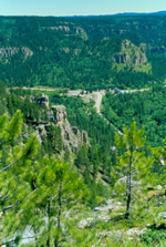
 West of Terry Peak turnoff, the road follows Icebox Canyon and drops 1,000 feet in 3 miles to Cheyenne Crossing. Here, the gorge turns north, where the Canyon’s Scenic Byway begins, and drops an additional 1,600 feet in 20 miles to Spearfish. West of Terry Peak turnoff, the road follows Icebox Canyon and drops 1,000 feet in 3 miles to Cheyenne Crossing. Here, the gorge turns north, where the Canyon’s Scenic Byway begins, and drops an additional 1,600 feet in 20 miles to Spearfish.
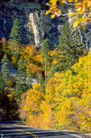
From Cheyenne Crossing to Savoy, the green shale of the Deadwood Formation (greater than 500 mya) is at the base of the cliffs, and the dominant tan-gray Madison limestone (320 mya) caps the top. For a mile between Elmore, an old lumber camp and switching station, and the mouth of Annie Creek, and again at the confluence of Rubicon Gulch, the highway cuts through the dark-gray igneous rock. Between Savoy and the mouth of the canyon at Spearfish, the sedimentary strata dip down to the north more steeply than the gradient of Spearfish Creek. One after the other, each of the formations exposed in the canyon walls disappears beneath the valley floor. At Rubicon, the tributary creek can not erode its valley fast enough to keep pace with the main stream, and the result is a hanging valley that ends in a cascade, known as Bridal Veil Falls. About a mile below Bridal Veil, the shale of the Deadwood Formation dips below the valley floor, followed by the orange-and-brown Whitewood Dolomite, then the tan and weathered-gray Madison Limestone, and finally, the upper yellow sandstone of the Minnelusa Formation (286 mya). At the very mouth of the canyon, the highway cuts through a narrow slot in the pinkish-red Minnekahta Limestone (230 mya) and emerges into the Spearfish Valley.
Spearfish Canyon is a work in progress. Much of it is the soft, erosive Limestone. Rain washes mud from the hill sides and the creek attacks its banks and bed just as the rains and streams did 50 million years ago. The present view of the canyon is not the last frame in the moving picture show of the beautiful feature.
Grand Canyon and Spearfish Canyon Comparison
 Everyone knows the Grand Canyon. It is much larger than Spearfish Canyon. It was designated a National Monument in 1908 and given federal protection.. It is located in a metro region that promotes 4-million visitors a year. It has been photographed in all the Journals and filmed in many Hollywood movies. The majestic baron and rocky sidewalls of the huge gorge dwarfs the visitor who stands at its rim.. Public access is mainly from the rim, although a few brave the whitewaters of the large Colorado River that flows through its spin. Everyone knows the Grand Canyon. It is much larger than Spearfish Canyon. It was designated a National Monument in 1908 and given federal protection.. It is located in a metro region that promotes 4-million visitors a year. It has been photographed in all the Journals and filmed in many Hollywood movies. The majestic baron and rocky sidewalls of the huge gorge dwarfs the visitor who stands at its rim.. Public access is mainly from the rim, although a few brave the whitewaters of the large Colorado River that flows through its spin.
Unlike the Grand Canyon, Spearfish Canyon offers no public roadway access to the rim. The only access is along a narrow two-lane highway winding in unison with Spearfish Creek through the spine. The view is always close and upward for the 1-million visitors. Much of the view is obscured by the tall and lush green vegetation. The new ‘76 Trail is the first formal access to the rim, and a few more trails are planned.
As Frank Lloyd Wright explained in his visit of 1935, “had Spearfish Canyon been on the ’throughway’ to westward migration, the canyon would be as significant in public appreciation as the Grand Canyon is today”.
Contributors: Dr. Alvis L. Lisenbee, Dept. of Geology and Geological Engineering, SDSMT, and excerpts from “Roadside Geology of South Dakota: Dr. Paul Gries
|


